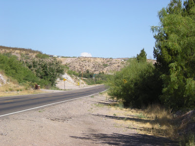
Banner Clouds
During monsoon season, the higher mountains across the Southwest form banner clouds, which float above the mountains like billowy white banners, hence their name.
The mechanism is as follows: During the morning hours, the hot sun beats upon the exposed mountainsides, heating the air. Like a hot air balloon, this hot air rises, cooling as it goes. Eventually the hot air cools enough so that the water vapor it contains condenses out, forming a cloud. Banner clouds are more likely to form during monsoon season because the air is more humid to begin with. The more water vapor in the air, the more likely a cloud is to form. One reason mountains are so wet -- with pine trees, creeks, and riparian habitats -- is because the banner clouds tend to rain straight down onto the mountains that produced them. A daily monsoon cycle is formed -- high humidity, banner clouds, and rain, which produces more high humidity, more banner clouds, and more rain, and so forth. Often it rains every day in the mountains.
These cumulonimbus banner clouds can reach an altitude of 30,000 feet or more, which means it's possible to see the banner cloud when the mountain itself is below the horizon. From Las Cruces, the most commonly-visible banner clouds form over the 10,000-foot Black Range, located southwest of Truth or Consequences; the 10,200-foot San Mateo Mountains located northwest of T or C; and 12,005-foot Sierra Blanca, located northeast of Alamogordo.
An easy way to identify banner clouds is to use a highway map and a compass. Place the compass over your location, and align the map so that magnetic north on the map points in the same direction as your compass. If the map doesn't have magnetic north, align the map with the compass, and then rotate the map 9 degrees clockwise to compensate for the fact that magnetic north is 9 degrees east of due north in our location. If you see clouds on the horizon, you can easily tell from the map which mountains are causing them.
The best time to see banner clouds is late morning, after they've had a chance to build up. Usually by early afternoon, local clouds are starting to form, which obscure the more-distant banner clouds.


1 Comments:
Cool bit of science with accompanying time lapse photos...
Good bit of counsel on the use of a map and compass too...
thanks
Post a Comment
<< Home